Subsurface heat content anomalies increase in Pacific Ocean
Surf News Network, 4 December, 2014 – During November 2014, sea surface temperature (SST) anomalies increased across the central and eastern equatorial Pacific. At the end of the month, the weekly Niño indices ranged from +0.4oC in the Niño-1+2 region to +1.0oC in the Niño-3.4 region.
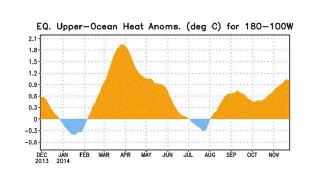
The subsurface heat content anomalies (averaged between 180o-100oW) also increased during November as a down-welling oceanic Kelvin wave increased subsurface temperatures in the central and eastern Pacific.
However, the overall atmospheric circulation has yet to show a clear coupling to the anomalously warm waters. The monthly equatorial low-level winds were largely near average, although weak anomalous westerlies appeared in a portion of the eastern tropical Pacific. Upper level easterly anomalies emerged in the central and eastern tropical Pacific during the month.
The Southern Oscillation Index has been somewhat negative, but the equatorial Southern Oscillation Index has been near zero. Also, rainfall continued to be below average near the Date Line and over Indonesia, and near average east of the Date Line.
Although the SST anomalies alone might imply weak El Niño conditions, the patterns of wind and rainfall anomalies generally do not clearly indicate a coupling of the atmosphere to the ocean. Therefore, despite movement toward El Niño from one month ago, the combined atmospheric and oceanic state remains ENSO-neutral.
Similar to last month, most models predict SST anomalies to be at weak El Niño levels during November-January 2014-15 and to continue above the El Niño threshold into early 2015. Assuming that El Niño fully emerges, the forecaster consensus favors a weak event. In summary, there is an approximately 65% chance of El Niño conditions during the Northern Hemisphere winter, which are expected to last into the Northern Hemisphere spring 2015 (click CPC/IRI consensus forecast for the chance of each outcome).
This discussion is a consolidated effort of the National Oceanic and Atmospheric Administration (NOAA), NOAA’s National Weather Service, and their funded institutions. Oceanic and atmospheric conditions are updated weekly on the Climate Prediction Center web site (El Niño/La Niña Current Conditions and Expert Discussions).
Forecasts are also updated monthly in the Forecast Forum of CPC’s Climate Diagnostics Bulletin. Additional perspectives and analysis are also available in an ENSO blog. The next ENSO Diagnostics Discussion is scheduled for 8 January 2015.
El Nino is a cycle of slightly higher than normal ocean current temps at the surface along the central to east equatorial pacific (Ecuador & Peruvian coast). Warmer temps on the ocean warm the atmosphere which is where fetch winds are which is the source of our surf. El Nino occurs every 4-12 years and last about 9-12 months developing late summer, peaking December-April. It sets off a chain reaction. The breaking down of High Pressures, the dropping of the Jet Stream and stronger, closer storms for Hawaii.