Good news for Buoys & Wave riders esp. just in time for Summer! We’ll have it up on SNN shortly so you can get it all in one spot. Ty!
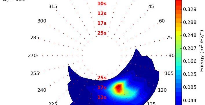
This new PacIOOS wave buoy is near the entrance to Pearl Harbor (CDIP #233; NDBC #51211). It measures waves within Māmala Bay approximately 1.5 miles (2.4 km) offshore of Pearl Harbor and approximately 1 mile (1.6 km) offshore of Honolulu International Airport along the South Shore of Oʻahu in the State of Hawaiʻi. Data are transmitted every half hour. Moored in water 35 meters deep, this Datawell Directional Waverer It measures waves within Māmala Bay approximately 1.5 miles (2.4 km) offshore of Pearl Harbor and approximately 1 mile (1.6 km) offshore of Honolulu International Airport along the South Shore of Oʻahu in the State of Hawaiʻi.
Data are transmitted every half hour. Moored in water 35 meters deep, this Datawell Directional Waverider DWR4 buoy is equipped with three accelerometers measuring north/south, east/west, and vertical displacements, allowing it to measure both wave direction and wave energy.
The location of the buoy has been issued as a Notice to Mariners and will be included on nautical charts; however, the buoy is constantly in motion and can drift from its charted position. To keep the buoy and its sensors operational, vessel operators and other ocean users are asked to maintain a stand-off distance of at least 300 feet to avoid collisions and damage to the buoy. Boaters, kayakers, and stand-up paddlers are asked to refrain from tying to the equipment and to avoid fishing near the buoy.
The Pearl Harbor wave buoy is owned and managed by PacIOOS.