
A south swell is expected to combine with “king tides” this weekend to produce coast flooding in low-lying areas.
Hawai’i, Maui, Moloka’i, Lana’i, O’ahu, Kaua’i
(May 25-26; June 23-24; July 21-22)
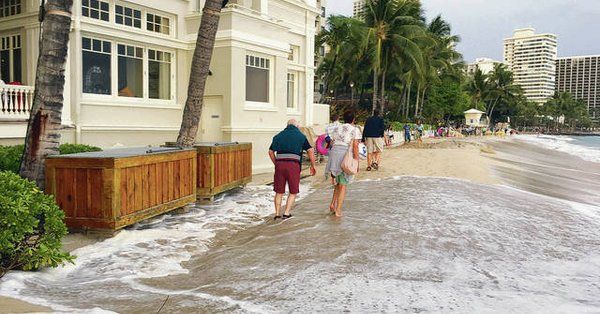
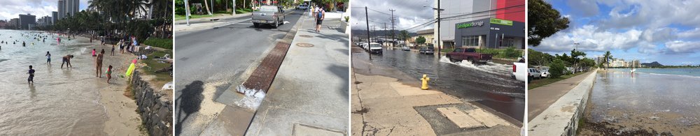
Federal & Local forecasters warn us: Hawaii’s shorelines will likely flood over the weekend as record-level spring “king tides” combine with a large summer swell.
The Honolulu National Weather Service posted the statement Wednesday: coastal flooding plus erosion likely across the entire island chain for the holiday weekend. South shore beaches like Oahu’s Waikiki are most at risk.
Plus, the South swell SNN’s been talkin’ about for 10 days builds on Friday and peaks Saturday at well above advisory criteria of 8′! We will see some spots hit 12′ faces or crest to trough! The large SSW angled surf with still be 10′ faces Sunday and 9′ in the face (5′ local scale) through Memorial Day! Combined with the highest tides of the year, known as king tides, forecasters expect water levels in Honolulu to reach peak levels Friday and Saturday evenings.
A similar tide was experienced on the last weekend of April when Honolulu reported its highest tide on record.
KHON coverage
For the King Tides all Islands May, June, July GO HERE and don’t forget our own Tide Charts right here on SNN!
What and Why
Hawaiʻi-specific projections are in line with global projections of sea level rise (SLR) with a mean height of 3 feet by 2100 (1). In addition, the existing problems of chronic erosion in Hawaiʻi, which causes beach loss, damages homes and infrastructure and endangers critical habitat, will likely worsen with SLR.
A key message for Hawai‘i and Pacific Islands from the National Climate Assessment, with respect to SLR is, “Rising sea levels, coupled with high water levels caused by tropical and extra-tropical storms, will incrementally increase coastal flooding and erosion, damaging coastal ecosystems, infrastructure, and agriculture, and negatively affecting tourism.” Additionally, low-lying islands and atolls will be particularly vulnerable due to their “small land mass, geographic isolation, limited potable water sources, and limited agricultural resources. [SLR] will increase saltwater intrusion from the ocean during storms.”
![]()
Hawai‘i Sea Grant is the Hawai‘i and U.S.-affiliated Pacific Islands project lead as part of the International King Tides Project – Snap the Shore, See the Future. Explore this interactive StoryMap featuring King Tides projects from around the world.
Click here to check it out!


One Comment
warning:
..king tides very dangerous @ Portlock Road (300-450 block due the safest path has been gated and locked by a resident
who wants to keep the public from using it.