King tides are simply the very highest tides. They are naturally occurring predictable events.
“King tide” is a colloquial (informal) term for an especially high spring tide, such as a perigean spring tide. “King tide” is not a scientific term, nor is it used in a scientific context. Use of the term “king tide” originated in Australia, New Zealand and other Pacific nations to refer to an especially high tide that occurs only a few times per year. The term has now come to be used in North America as well…The king tides occur when the Earth, Moon and Sun are aligned at perigee and perihelion, resulting in the largest tidal range seen over the course of a year. So, tides are enhanced when the Earth is closest to the Sun around January 2 of each year. They are reduced when it is furthest from the Sun, around July 2. The predicted heights of a king tide can be further augmented by local weather patterns and ocean conditions.
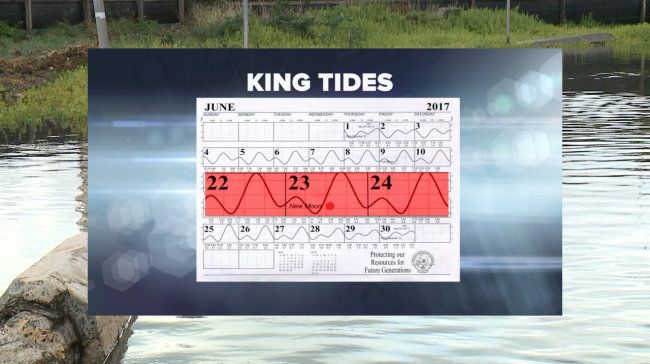
The next king tide comes July 21-22.
Mahalo to Dolan Eversole at the University of Hawaii Sea Grant College Program & Waikiki Beach Management Coordinator
for putting this together….
- Still water levels are currently about six-eight inches elevated water level ABOVE predicted tides.
- The June 22-25th high tide event will be similar to April and May events, exceeding 3 ft of still water level. There is a slightly higher predicted tide but the regional anomaly is smaller now than April/May.
- Parts of Waikiki Beach will fully be inundated at high tide with thin sheet flow wave run up with tide levels plus wave run up above 3.5ft above mean Sea level. Other low areas may experience recurrent flooding and ponding similar to the last event in May.
- The National Weather Services has issued an advisory level south swell this week Tues-Wed with another possibly advisory-level swell on Thurs-Fri, so high water levels associated with wave runup will be a probable all week.
- Impacts should be similar to April-May events, which also coincided with the south swell; including unusually high wave run-ups, localized coastal erosion, and temporary flooding in some low-lying shoreline areas, particularly along South shores.
- Monitor the weather forecast for heavy rainfall as this will exacerbate tide-related drainage and ponding issues. The forecast currently looks ok for rain and weather during the high tide episode.
- You may want to consider taking mitigative measures to prevent flooding from wave run up and low elevation groundwater inundation (basements and parking garages). The preventative measures utilized in the past 2 events may be appropriate for this week’s high tides as needed. The State DLNR is advising all emergency sandbags and associated flood mitigation material needs to be removed from the beach immediately after the high tides subside. If you have questions or concerns on what to do contact me for assistance.
DESCRIPTION:
The highest water levels of the summer are expected around the upcoming peak astronomic tides of the year, known as “king tides,” occurring over a few days around June 23-24 and July 21 in Hawaiʻi. These may produce flooding events similar to what occurred in late April and May. University of Hawaiʻi researchers says summer will provide a glimpse of what will eventually become routine with continued global warming and sea-level rise.
Localized impacts may include coastal erosion, wave over-wash and temporary flooding in low-lying backshore areas around storm drain systems. Impacts may be more severe if the upcoming king tides coincide with an elevated surf event, which occurs most often on the south and east shores this time of year, and/or during heavy rains. Actual water levels along exposed coasts will largely depend on wave heights during the high tides.
In 112 years of record keeping for Honolulu, the highest recorded (non-storm) water level was measured on April 28, 2017.
The highest astronomical (lunar) tides of the year will occur this Friday, June 23rd and Saturday, June 24th in the late afternoon and again on July 21-22, which is typical of this time of year.
What is unusual is that Hawaii continues to experience about six inches of elevated water level, on top of predicted tides.
What are the potential impacts?
Flooding at the shoreline will depend largely on wave conditions and weather.
Highest waves during this time of year typically occur on south and windward coasts
Localized impacts may include:
o Coastal erosion
o Wave overwash and flooding, particularly on south and windward coasts
o Temporary ponding in low-lying areas
o Reduced drainage and flooding around coastal storm drain, especially if there is heavy rainfall.
o Impeded beach access, with hazardous conditions possible
For more information and links to forecast products visit www.hawaiisealevel.org.