We’ve seen it’s effect in the booming tropics and its only a matter of time the NPAC will be positively effected from surfers point of view next couple seasons.
Up to 90% chance El Niño will continue through Northern Hemisphere winter
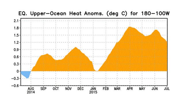
Surf News Network, 11 July, 2015 – During June, sea surface temperatures (SST) anomalies exceeded +1.0oC across the central and eastern equatorial Pacific Ocean. The largest SST anomaly increases occurred in the Niño-3 and Niño-3.4 regions, while the Niño-4 and Niño-1+2 indices remained more constant through the month.
Positive subsurface temperature anomalies weakened due to the eastward shift of an upwelling oceanic Kelvin wave, which reduced above-average temperatures at depth in the central and east-central equatorial Pacific. In many respects, the atmospheric anomalies remained firmly coupled to the oceanic warming. Significant westerly winds were apparent in the western equatorial Pacific and anomalous upper-level easterly winds continued.
The traditional and equatorial Southern Oscillation Index (SOI) were both negative, which are consistent with enhanced convection over the central and eastern equatorial Pacific and suppressed convection over Indonesia (Fig. 5). Collectively, these atmospheric and oceanic features reflect an ongoing and strengthening El Niño.
Nearly all models predict El Niño to continue into the Northern Hemisphere winter 2015-16, with many multi-model averages predicting a strong event at its peak strength (3-month values of the Niño-3.4 index of +1.5oC or greater. At this time, the forecaster consensus is in favor of a significant El Niño in excess of +1.5oC in the Niño-3.4 region. Overall, there is a greater than 90% chance that El Niño will continue through Northern Hemisphere winter 2015-16, and around an 80% chance it will last into early spring 2016 (click CPC/IRI consensus forecast for the chance of each outcome for each 3-month period).
Across the contiguous United States, temperature and precipitation impacts associated with El Niño are expected to remain minimal during the Northern Hemisphere summer and increase into the late fall and winter (the 3-month seasonal outlook will be updated on Thursday July 16th). El Niño will likely contribute to a below normal Atlantic hurricane season, and to above-normal hurricane seasons in both the central and eastern Pacific hurricane basins (click Hurricane season outlook and how Ela made history HERE)
This discussion is a consolidated effort of the National Oceanic and Atmospheric Administration (NOAA), NOAA’s National Weather Service, and their funded institutions. Oceanic and atmospheric conditions are updated weekly on the Climate Prediction Center web site (El Niño/La Niña Current Conditions and Expert Discussions).