

Surf News Network October, 2016 – ENSO-Neutral conditions were observed during September, with negative sea surface temperatures (SSTs) anomalies expanding across the eastern equatorial Pacific Ocean by early October.
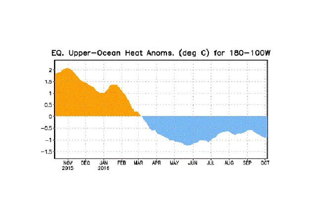
All of the Niño regions cooled considerably during late September and early October, with the latest weekly value of Niño-3.4 index at -0.9°C. Subsurface temperature anomalies also decreased toward the end of the month, reflecting the strengthening of below-average temperatures at depth in the east-central equatorial Pacific. Atmospheric anomalies across the equatorial Pacific edged toward La Niña during September, with a stronger tendency toward La Niña late in the month.
The traditional Southern Oscillation index and the equatorial Southern Oscillation index were positive. The lower-level winds were near average across most of the basin during the month, but enhanced easterlies were becoming more persistent west of the International Date Line.
Upper-level winds were anomalously westerly near and just east of the International Date Line. Convection was weakly suppressed over the central tropical Pacific and was more enhanced over Indonesia compared to last month. Overall, the combined ocean and atmosphere system reflects ENSO-Neutral during September, but are more clearly trending toward La Niña conditions.
The multi-model averages favor borderline Neutral-La Niña conditions (3-month average Niño-3.4 index less than or equal to -0.5°C) persisting during the Northern Hemisphere fall and continuing into the winter. Because of the recent cooling in the Niño-3.4 region and signs of renewed atmospheric coupling, the forecaster consensus now favors the formation of a weak La Niña in the near term, becoming less confident that La Niña will persist through the winter.
In summary, La Niña is favored to develop (~70% chance) during the Northern Hemisphere fall 2016 and slightly favored to persist (~55%% chance) during winter 2016-17.
This discussion is a consolidated effort of the National Oceanic and Atmospheric Administration (NOAA), NOAA’s National Weather Service, and their funded institutions. Oceanic and atmospheric conditions are updated weekly on the Climate Prediction Center web site (El Niño/La Niña Current Conditions and Expert Discussions).
Forecasts are also updated monthly in the Forecast Forum of CPC’s Climate Diagnostics Bulletin. Additional perspectives and analysis are also available in an ENSO blog. The next ENSO Diagnostics Discussion is scheduled for 10 November 2016 .
Cooler-than-normal sea surface temperatures in the central-eastern tropical Pacific ocean have continued and deepened during September as compared to August. Sea surface temperature is one criteria that climate experts use to monitor and predict La Niña—the cool phase of the ENSO climate pattern. Cooler sea surface temperature combined with other criteria which involve the atmosphere have helped lead this month to experts re-issuing a La Niña watch.
The map at right shows where surface temperatures of the Pacific Ocean in August 2016 were cooler (blue) or warmer (orange and red) than the 1981-2010 average. The darker the color, the larger the temperature departure.
Climate experts keep a close eye on the tropical Pacific Ocean because it is at the heart of ENSO. Short for El Niño-Southern Oscillation, ENSO is a powerful natural climate pattern in which the central/eastern tropical Pacific swings back and forth between a warm and rainy state (El Niño) and a cooler and drier state (La Niña).
El Niño and La Niña disrupt wind, air pressure, and rainfall patterns throughout the tropics. The disruptions can have side effects on global climate, including shifting the location of the mid-latitude jet streams that guide storms towards the United States.